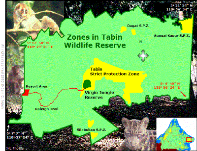
ZONES The approximately 120,000 ha. area of Tabin Wildlife Reserve includes three different categories of forest reserve that are designated as Class VII Wildlife Reserve, Class I Protection Forest Reserve and Class VI Virgin Jungle Reserve. Much of Tabin includes the former Silabukan and Lumerau Forest Reserves and is gazetted as Class VII Wildlife Reserve. Much of this was subjected to selective logging until the 1980s but a central "core area" of unlogged forest, comprising 8,816 ha. Has been designated as primary forest to provide a refuge for animals disturbed by logging. since 1992 this core area has been designated as Class I Protection Forest. |
|
| Within the total reserve area are seven Virgin Jungle Reserves (VJR's) providing total protection to small patches of forest which are of particular scientific interest. The largest of these is Sungai Kapur VJR; an area of 1,250 ha that forms the north-east corner of Tabin. The Tabin VJR (283 ha) and the Lipad VJR (110 ha) both include mud volcanoes. There is a pair of small VJR's in the low lying north-central part of the reserve that is collectively designated as the Dagat VJR (181 ha.). In the mountainous southern peninsula of Tabin a further pair of zones comprise the Silabukan VJR (194 ha.). Thus the total area of all seven VJR's is 2,018 ha. The Forest Department is legally responsible for all categories of forest reserve. However, by administrative agreement, the Sabah Wildlife Department has been responsible for all matters concerned with wildlife management in Tabin since its formation in 1988. In Tabin the Forest Department attends to enforcement of forest and habitat protection regulations while the Wildlife Department enforces regulations directly relevant to the protection of wildlife. Logging and any other form of modification of the vegetation- is illegal in both Class I Protection Forests (the Tabin core area) and Virgin Jungle reserves. It is not legally forbidden in Class VII Wildlife Reserves and hunting is legally possible in both Wildlife Reserves and Protection Forest Reserves but in practice hunting and logging licenses are no longer issued for any species within reserve boundaries. |
BOUNDARIES The total length of Tabin�s boundary as estimated from maps is about 310 km but on the ground this distance would be considerably greater due to the undulating terrain that prevails along most of the boundary. The state of the boundary is clearly marked on the ground by permanent and visible features in the following areas:
-
South-western corner to Sungai Lipad by the reserve road/estate boundary Area of the north-western corner by the Segama River.
-
Northern boundary as far East as Sungai Tabin by the estate boundary/fence.
-
Northern boundary from Sungai Tabin to north by the eastern corner by a clear area.
-
South-western corner of southern peninsula portion west to the south-west corner of the reserve by the reserve/Sabah Cocoa Estate boundaries.
-
The straight line running south from the northeast corner to the southeast corner adjacent to a narrow strip of unalienated buffer zone between the reserve and the FELDA Sahabat Scheme the boundary of which is defined by a triple barrier consisting of a trench, an electric fence and a sheet metal pig barrier.
The straight line going north from Sungai Lipad River to the Segama River is not demarcated and is adjacent to a narrow strip of an unalienated buffer zone between the reserve and Kretam Estate. The eastern half of the southern boundary from the south-eastern corner west as far as the south-western corner of the peninsula is not demarcated and in some portions is adjacent to forest land which not cleared. This makes the reserve boundary impossible to identify with precision. |